CUSTER-GALLATIN CALL TO ACTION

Your help is needed! Custer-Gallatin National Forest has released its Draft plan. The public comment period ends Thursday, June 6, 2019.

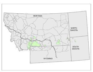
This Forest encompasses more than three million acres in SW Montana and South Dakota. There are six mountain ranges within the Forest complex.

Montana Liaison Ron Normandeau says this Draft “portrays a prejudice against airstrips and aircraft access.” We need to provide positive input advocating airstrips before the comment deadline on June 6.

Ron has excerpted the following relevant language regarding Airfields. Please refer to it before commenting:

2.4.12 Airfields, Aircraft Landing Strips (AIRFIELDS)

Introduction

The Custer Gallatin National Forest does not manage any public or administrative airfields as part of the transportation system. The forest owns taxiways and tarmacs at the West Yellowstone Airport in support of the smokejumper and air tanker base. No public sites have been designated or authorized on the Custer Gallatin National Forest.

Desired conditions under general recreation apply to public recreational motorized aircraft landing strips.

Standards (FW-STD-AIRFIELDS)

01 Public recreational motorized aircraft landing and take-off shall only be allowed at designated and authorized sites.

02 Any new landing and take-off locations shall be constructed, maintained, and operated by the holder of a special use authorization.

Suitability (FW-SUIT-AIRFIELDS)

01 Backcountry aircraft landing strips are not suitable in designated wilderness, the Hyalite Porcupine Buffalo Horn Wilderness Study Area, the Cabin Creek Recreation Wildlife Management Area, National Natural Landmarks, the Wild Horse Territory, research natural areas, special areas, recommended wilderness areas, within ¼ mile each side of eligible wild rivers, within ½ mile each side of the Continental Divide Trail, riparian management zones, areas of primitive or semi-primitive nonmotorized recreation opportunity spectrum, or within the grizzly bear recovery zone. Backcountry aircraft landing strips are suitable in areas of rural, roaded natural and semi-primitive motorized recreation opportunity spectrum, outside of the designated areas listed in the preceding sentence.

Alternative D: Backcountry aircraft landing strips are not suitable anywhere on the Custer Gallatin National Forest.

Talking points to use in your comments.

1. Airstrip section portrays a forest prejudice against aircraft access.

2. Airfields Desired conditions under general recreation does not provide adequate guidance to future planners for the establishment of forest access by aircraft.

3. Desired conditions do not meet Planning Directives standards for presentation of the plan component; Desired Condition.

Excerpt from Plan Directive:

Desired conditions must be described in terms that are specific enough to allow progress toward their achievement to be determined, but do not include completion dates. (36 CFR 219.7(e)(1)(i)) Forest Service Handbook FS1909.12, Chapter 20, Sec 22.11 page 22

4. The airfields section does not address the five plan components: Desired Condition, Objectives, Standards, guidelines, and suitability. The directives require all five components to define an activity.

5. Excerpt from Plan Directive:

Plans must include the following plan components (36 CFR 219.7): desired conditions (sec. 22.11), objectives (sec. 22.12), standards (sec. 22.13), guidelines (sec. 22.14), and suitability of lands (sec. 22.15). Goals may be included as an optional plan component (sec. 22.16). Forest Service Handbook FS1909.12, Chapter 20, Sec 22.1 page 20

6. Under Suitability the list of areas “unsuitable for aircraft landing strips” is unsupported by law accept for designated wilderness and research natural areas.

7. Draft Environmental Impact Statement does not present any data on aircraft operations impact on the environment.

It’s easy to comment —Here’s how:

• Online at: https://tinyurl.com/caracgnf

• Email to cgplanrevision@fs.fed.us. Use Subject line “Comment – draft plan – CGNF”

By Mail to Custer Gallatin National Forest, Attn: Forest Plan Revision Team, P.O. Box 130, (10 E Babcock), Bozeman, MT 59771
The RAF has participated respectfully in previous Forest Plans with success. Please take a moment to comment. Your voice matters!

Submitted on May 28, 2019


Posted in Calls to Action

Recent Posts

April 5, 2026
FEATURING: THE RAF DOG COLLECTION MODELED BY JOSIE & MUD Outfit your four-legged co-pilot for every adventure! From airplane rides to backcountry trails, this collection has everything they need to travel in comfort and style. Featuring two new additions—a stainless steel Orvis dog bowl and DawgMuffs—alongside RAF favorites like the collar, leash, and bandana. This collection includes items designed and created by RAF supporters. Shop the Dog Collection here. If you have questions, please email contact@theraf.org or call 406-582-1723. Your RAF Outfitter purchase is greatly appreciated and furthers the mission to preserve, improve, and create airstrips for recreational access. You can support the RAF mission all year by shopping at the RAF Outfitter online store. Products are being added regularly, and items are thoughtfully selected for durability and suitability for pilots, by pilots. We welcome photos of supporters using RAF gear! Please send your images to ewhite@theraf.org , and let us know if we have permission to post them on social media or our website. Submitted April 5, 2026.
By lellington April 3, 2026
Call To Action Volunteer
March 30, 2026
As you're planning your 2026 flying adventures, remember to review safety briefings for the airstrips you plan to visit. The RAF strongly recommends you review safety briefings and print a copy to have in your airplane - it's even required to fly into some airfields, like Ryan Field (2MT1). For those airfields, pilots flying in are required to review the briefing on an annual basis, and now is the perfect time to catch up on any changes to the runway/area that happened throughout the winter. You can find safety briefings on the RAF Airfield Guide . If an airfield in the Airfield Guide has a required briefing, the airfield listing will clearly indicate it and have a tab to view the briefing. Submitted March 30, 2026 Photo By Jim Stevenson
March 30, 2026
RAF Texas volunteers and Ranger Airfield Foundation volunteers helped begin restoration of the historic 1928 Ranger Airfield hangar on March 28. “A Wright biplane landed here at the field in 1911, and people have been using it ever since,” Ranger Airfield Foundation Founder Jared Calvert said. He noted that Amelia Earhart landed there in a Pitcairn Auto Gyro. Richard Bach, Pancho Barnes, and General Patton also landed at the field. It’s the oldest continuously used turf field in Texas. 
By Carmine Mowbray March 30, 2026
For adventurers seeking access to the Gila Wilderness, we suggest landing at Sacaton Airstrip, NM16, near Buckhorn, New Mexico. The runway lies on a “finger mesa,” and the Rain Creek trailhead lies just northeast of the field. Thanks to RAF New Mexico Liaison Ron Keller's coordination with the USFS using a Cost Share Agreement, Keller was able to organize RAF and New Mexico Pilot Association (NMPA) volunteers to rehabilitate and reopen the long-abandoned airstrip in 2022. Beyond reopening the airstrip, Keller added camping amenities, including picnic tables and a new vault toilet. Most recently, Keller oversaw the installation of new shade structures, most welcoming to campers and hikers. RAF and NMPA volunteers complete ongoing maintenance at Sacaton and other airfields in the Gila National Forest. You’ll see white-painted rocks along Sacaton’s 3,989-ft dirt runway, and surrounding the segmented circle near the RAF windsock. The airstrip lies at 6,200-ft elevation, so pilots should be mindful of density altitude while flying over high terrain in the vicinity, even in winter temperatures.  “Anglers will enjoy plying streams for the rare native copper-colored Gila trout, once a threatened species,” Keller reports. The mile-and-a-half trail to the crossing at Rain Creek is narrow and challenging and traverses a variety of terrain, but the serious hiker will be rewarded trekking through steep canyon walls lined with green alder, willow, and boxelder, hoodoos, and eagle aeries above. There are rumors of a double waterfall some distance on the west fork of Rain Creek trail. See the Sacaton page in the Airfield Guide for more details. Note that the airstrip may be unusable due to snow or after heavy rains. This runway should be considered one-way in/one-way out to avoid overflying the Wilderness boundary. There is a 4.6% upslope to the East, favoring landing Runway 08 with right traffic, remaining clear of the Wilderness east and north of the airfield. Please consider others seeking a Wilderness experience. Prior to landing at Sacaton, permission is required by calling the USFS Gila Dispatch center at 800-538-1644. Please familiarize yourself with Sacaton in the Airfield Guide and the New Mexico Pilots Association Safety Briefing . Submitted March 30, 2025 By Carmine Mowbray