Featured Airstrip
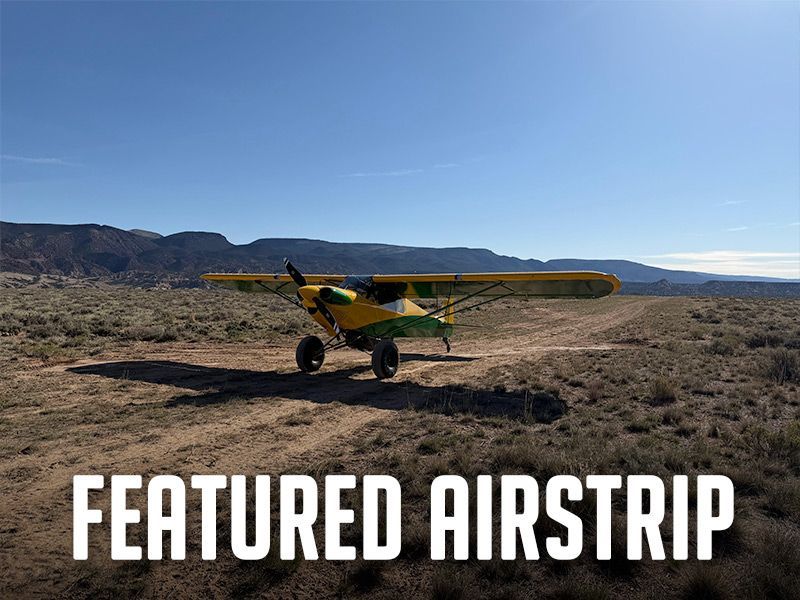
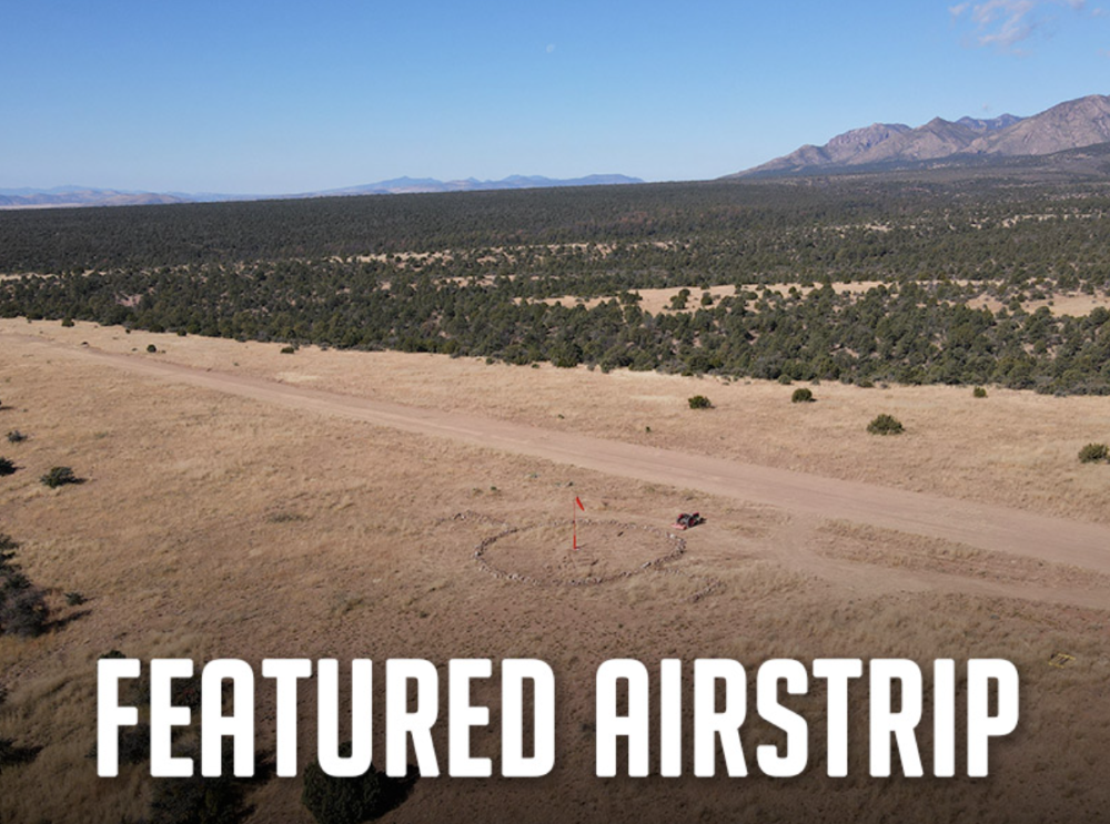
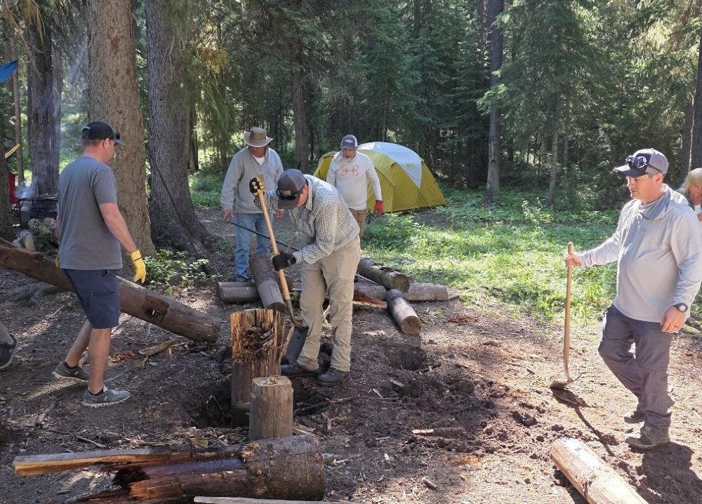
Landing and camping at Taylor Flat airstrip puts your tent only a stone’s throw from the wild and scenic Green River, as it carves through spectacular Utah canyons. You can tie down and camp under your wing along the north side of the airstrip, or walk to the river and camp. Just 34 nm northeast of Vernal, you can now land at this high, remote BLM airstrip and enjoy its world-class fly fishing, but be sure to get your license before you arrive. If you packed your kayak or inflatable, there’s a boat ramp just west of the public campground. An easy 1.8-mile walk from the airstrip takes you to the historic 1880 John Jarvie Ranch, an open-air museum with hands-on exhibits showing pioneer ranch life in this remote northeast corner of Utah. This airstrip had lain dormant for thirty years, and is now open for public non-commercial use, thanks to pilots who recognized its special recreational value. The RAF worked through the steps to see that the BLM reopened it. One restoration work weekend brought twenty-five volunteers from both Utah Back Country Pilots (UBCP) and the RAF who hand-picked rocks from the airstrip, painted them, and used them to mark the runway corners and thresholds. UBCP provided a new windsock pole for the new RAF windsock. RAF Utah Liaison Wendy Lessig said, “It was another demonstration of working together toward the same goal.” There are no other amenities, so be prepared with what you need, and as always, please pack everything out. Those using the airstrip are asked to be mindful of the sensitive environmental area, marked with 16-ft X’s, creating a displaced threshold on the east end of the dirt runway. The useable runway length is 2,500 feet, and the field elevation is 5,630. The area east of the runway is hazardous to aircraft operations. In addition to being a sensitive environmental area, it. is cross-crossed with ditches, and is not safe for aircraft use. Taylor Flat is another special recreational destination for pilots to visit as RAF works across the country on Expanding The Map! Find more on Taylor Flat in the Airfield Guide . You may also find user reports here on the UBCP website . Submitted July 31, 2026 By Carmine Mowbray
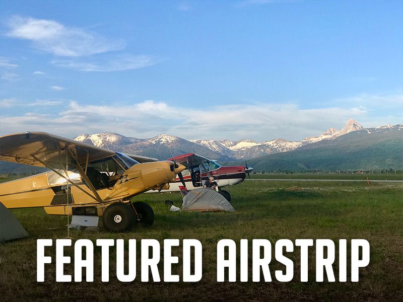
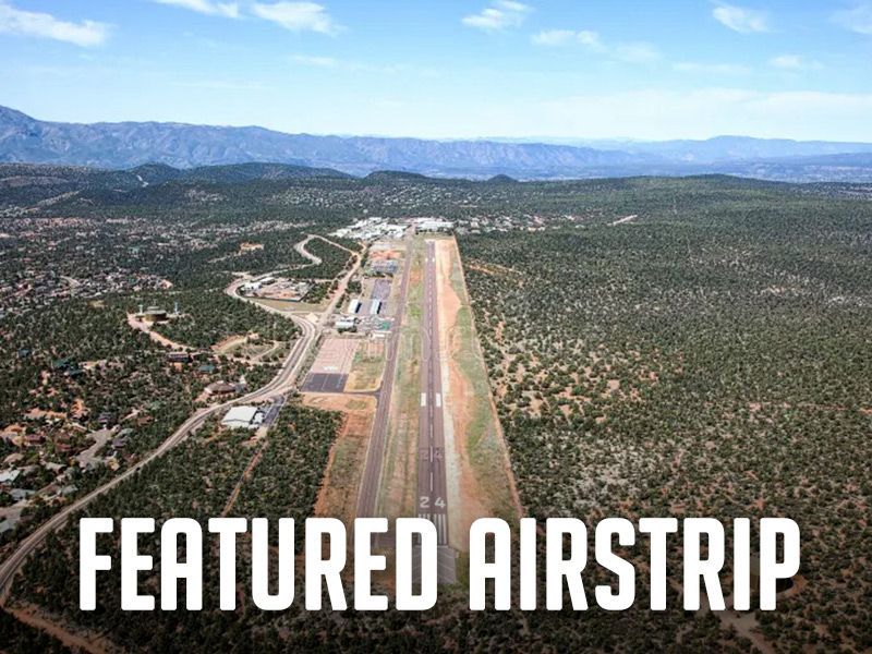
You’d have a hard time finding a more beautiful place to fly than Driggs-Reed Memorial Airport (KDIJ). The Grand Teton, Big Hole, and Snake River mountain ranges surround this eastern Idaho valley. Driggs has become a world-class destination for the pilot community. National Geographic magazine listed Driggs as “one of the ten best outdoor recreation destinations in the U.S.” Just a 45-minute drive over Teton Pass is Jackson, Wyoming, a famous Western destination. The airport, at an elevation of 6,257, accommodates aircraft on both its 7,300-ft paved runway and 3,000-ft turf landing area, marked with cones. Note: The SW 3,451 feet of the paved runway is closed until August for reconstruction. Check NOTAMS before landing. Fly-in visitors are welcome to camp underwing at its grassy tie-down area. It’s an ideal gateway to the Idaho backcountry. Enjoy views of the nearby Teton Range from the 12' x 16' cedar pilot shelter. There is potable water, a toilet, power, a gas barbecue, and a charging station nearby. Within walking distance of the campground is the Forage restaurant. A bike shed and loaner bikes, provided by the Idaho Aviation Association Borrow-A-Bike program, are available to ride into town. If you desire a more urban experience or wish to explore further, the airport has rental cars. “It’s a great destination for the pilot community, with access to hiking, biking, fishing, floating, golf and a small town with numerous shops and restaurants,” RAF Director and Driggs resident Tim Riley says. He and a local RAF supporter recently completed a spring cleanup to ready it for the season. The amenities were provided cooperatively through the RAF, the Idaho Aviation Association (IAA), the City of Driggs, and its Airport Board, with financial contributions from each. For more information on Driggs, see the Airfield Guide . Submitted July 1, 2026 By Carmine Mowbray
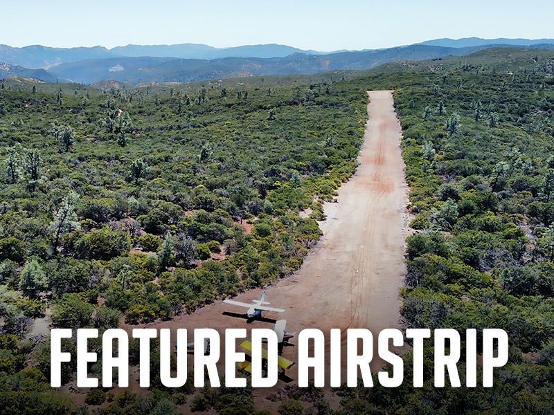
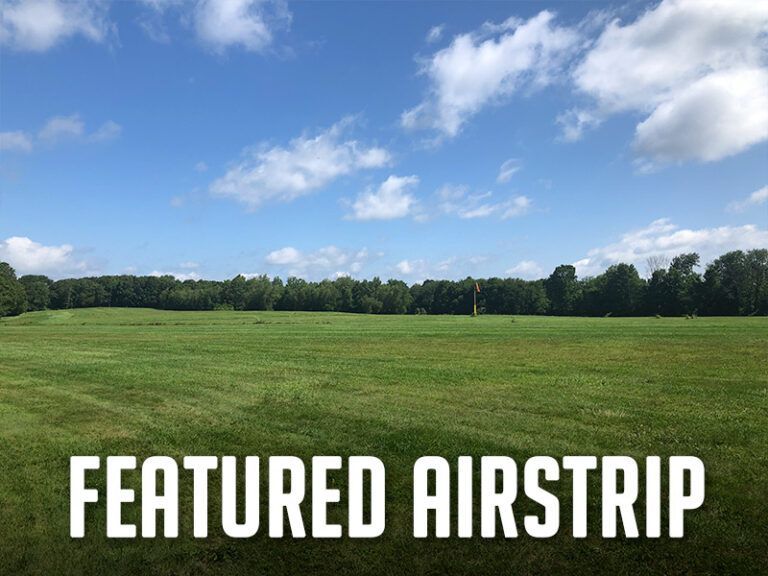
Thanks to the efforts of RAF California Liaison Doug Lumgair and dedicated volunteers, an abandoned, overgrown airstrip on BLM land has been reclaimed from encroaching vegetation. Now known as Walker Ridge, this northern California airstrip offers a remote, secluded experience within easy reach of pilots in the Sacramento/Central Valley and San Francisco Bay regions. Camping at the south end of the 1,800-ft strip offers a gorgeous view of the valley — and after dark, with no artificial lighting for miles, the night sky turns breathtaking. The recreational opportunities at this airstrip are plenty. Hunting is allowed in the area, which includes deer, wild boar, turkey, and quail. Along with this, biking and hiking trails surround the area, with a main trail that is located right next to the airstrip. Not far from Walker Ridge is Wilbur Hot Springs, a natural hot mineral spring centered within a nature preserve, and open to the public on a reservation basis. Lumgair’s organized work parties have been described as “magical” — as the stunning setting makes a deep impression on everyone. Pitch your tent and enjoy the valley overlook— beautiful at any time of day, especially because no structures are visible. Lumgair prepared a detailed work proposal for the BLM, and monitored the request throughout the agency's approval process. By October 2025, the RAF obtained approval to reclaim and rehabilitate the airstrip for increased safety and recreational access. The initial work on the overgrown strip proved challenging, beginning with the rough drive to the site and throughout the arduous removal of protruding boulders right in the runway. Now, the strip is usable by most backcountry-suitable aircraft, and pilots comfortable with a narrow runway. Please see the Airfield Guide for more information on Walker Ridge and videos. Note that there are no water or bathroom facilities available on site. Read more about Walker Ridge and how the RAF is Expanding The Map here . Submitted June 1, 2026 By Carmine Mowbray
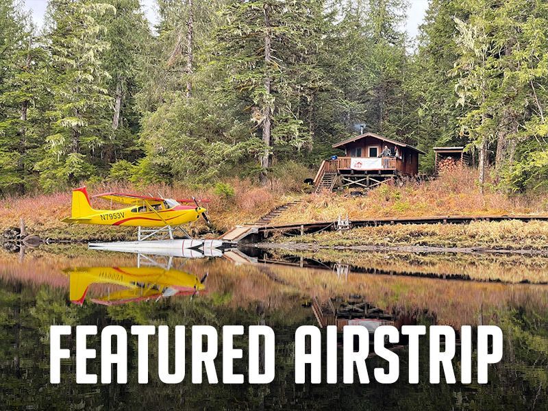
There are two fly-in public use cabins on Heckman Lake in the Ketchikan Misty Fjords Ranger District of Alaska. Both are approximately 15 miles from Ketchikan, and open year-round to welcome visitors for what RAF Alaska Liaison Jeff DeFreest calls “a very unique remote recreational experience. Relaxing on the deck gives you a view of the lake, surrounded by the Sitka Spruce and western hemlock forest.” Either site can be accessed by float plane or by boating into Naha Bay. Each cabin has a table, benches, a wood stove, and an outhouse. Guests should bring their own firewood, as it is not guaranteed. Drinking water is not available; guests should treat the creek or lake water, or bring their own. Southeast Heckman Fly-In Cabin is situated on the southeast shore of Heckman Lake and is only accessible by floatplane. The 16x22-ft pan-abode style log cabin accommodates eight people and is wheelchair accessible. In 2024, the RAF and Seaplane Pilots Association provided grants to restore the cabin. Volunteers, assisted by Misty Fjords Air, collaborated with the US Forest Service to complete work on the cabin, dock, outhouse, and trails. The other cabin is a 12x14-ft pan-abode style that can accommodate up to six people. It can be accessed by float plane or by boating into Naha Bay and hiking six miles on the Naha River National Recreation Trail. Visitors may use the 14-foot aluminum skiff with oars or bring their own short shaft motor. The Naha River is accessible from the cabins and provides opportunities to fish for trout. In season, there are steelhead and salmon runs. The Naha River National Recreation Trail winds downstream six miles through a rainforest where you may spot Roosevelt Lagoon, Jordan Lake, and a waterfall on your way to Naha Bay. Visitors would be wise to bring extra provisions, as occasionally, poor weather can cause extended stays. The RAF Airfield Guide includes information on these cabins. Recreation.gov allows visitors to check availability and find other USFS information on the Southeast Heckman Lake fly-in cabin and Heckman Lake cabin . Submitted April 30, 2026
For adventurers seeking access to the Gila Wilderness, we suggest landing at Sacaton Airstrip, NM16, near Buckhorn, New Mexico. The runway lies on a “finger mesa,” and the Rain Creek trailhead lies just northeast of the field. Thanks to RAF New Mexico Liaison Ron Keller's coordination with the USFS using a Cost Share Agreement, Keller was able to organize RAF and New Mexico Pilot Association (NMPA) volunteers to rehabilitate and reopen the long-abandoned airstrip in 2022. Beyond reopening the airstrip, Keller added camping amenities, including picnic tables and a new vault toilet. Most recently, Keller oversaw the installation of new shade structures, most welcoming to campers and hikers. RAF and NMPA volunteers complete ongoing maintenance at Sacaton and other airfields in the Gila National Forest. You’ll see white-painted rocks along Sacaton’s 3,989-ft dirt runway, and surrounding the segmented circle near the RAF windsock. The airstrip lies at 6,200-ft elevation, so pilots should be mindful of density altitude while flying over high terrain in the vicinity, even in winter temperatures. “Anglers will enjoy plying streams for the rare native copper-colored Gila trout, once a threatened species,” Keller reports. The mile-and-a-half trail to the crossing at Rain Creek is narrow and challenging and traverses a variety of terrain, but the serious hiker will be rewarded trekking through steep canyon walls lined with green alder, willow, and boxelder, hoodoos, and eagle aeries above. There are rumors of a double waterfall some distance on the west fork of Rain Creek trail. See the Sacaton page in the Airfield Guide for more details. Note that the airstrip may be unusable due to snow or after heavy rains. This runway should be considered one-way in/one-way out to avoid overflying the Wilderness boundary. There is a 4.6% upslope to the East, favoring landing Runway 08 with right traffic, remaining clear of the Wilderness east and north of the airfield. Please consider others seeking a Wilderness experience. Prior to landing at Sacaton, permission is required by calling the USFS Gila Dispatch center at 800-538-1644. Please familiarize yourself with Sacaton in the Airfield Guide and the New Mexico Pilots Association Safety Briefing . Submitted March 30, 2025 By Carmine Mowbray
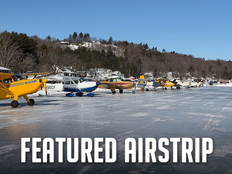
This month, we are featuring a most unique destination, Alton Bay, New Hampshire, B18, located on the southern edge of Lake Winnipesaukee. It’s a busy seaplane base during summer, and when winter chill descends on the countryside, the watercraft get stored, and eager pilots await New Hampshire’s DOT Aeronautical Division’s go-ahead for ice landings when they deem the ice is a safe thickness. Local volunteers get involved and mark the runway with cones, and keep the ice field, taxiway, and parking apron graded, typically through March. The RAF, alongside other local organizations, has played a role in keeping Alton Bay open and maintained over the years—helping fund fuel and equipment parts, and supporting the dedicated volunteers who work hard to keep the runway in excellent condition. Pilots enjoy the experience of landing on pure ice on New Hampshire’s largest lake – skis not required – and locals report a fantastic season this winter, logging more than last year’s record 764 landings. “Pilots eager to practice this New England winter tradition come from as far as New Jersey, Michigan, and the New England states to land, socialize, or walk the short distance to town for shopping, dining, and the surrounding amenities,” said New Hampshire Liaison John Meade. Alton Bay businesses warmly welcome visitors to their annual February Winter Carnival that draws large crowds for sleigh rides, ice skating, beer and chili bar, a chowder cook-off, and food and swag vendors. Find Alton Bay Ice Runway on the Airfield Guide and bookmark the Alton Bay Facebook page to check out photos, reels, reviews, and of course, current dialog. Those who pay a visit to B18 receive a coveted Ice Wing certificate and Ice Chip. Alton Bay Ice Runway is CLOSED for the season as of March 4th, 2026. Submitted February 27, 2026 By Carmine Mowbray Photo Credit: Greg Delp
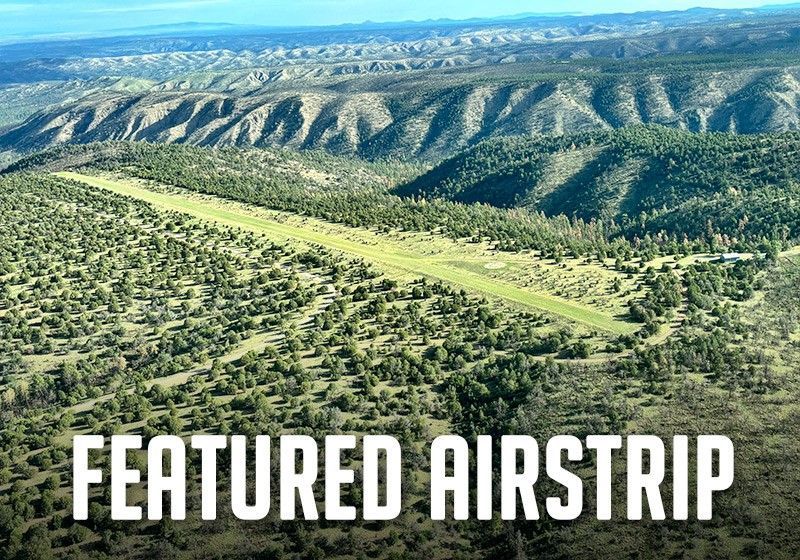
If you’re looking to extend your backcountry flying season in the Southwest, consider plans to visit New Mexico’s Gila National Forest. Me-Own, 28 nm NE of Silver City, is one of Gila’s several recreational USFS airstrips, and has a 3,700 x 50 foot runway at an elevation of 7,554 feet. You can count on cool summer days and moderate winters among the ranges of desert grasses and mountain forests of ponderosa pine, pinyon-juniper, aspen, spruce, and fir. The Gila’s USFS backcountry airstrips are cooperatively maintained by RAF and New Mexico Pilots Association (NMPA) volunteers and provide access to this remote and beautiful region of the state. Sacaton, Rainy Mesa, Beaverhead, Negrito, and Jewett Mesa are "comfortably long and level runways [that] create a flying paradise,” according to the NMPA. Paved Reserve airport serves as a base for NMPA's annual Gila Regional Fly-In. Me-Own, 1NM0 offers trail access to the Aldo Leopold Wilderness, just past the vault toilet. Here’s where you can join Section 23 of the Grand Enchantment Trail that stretches 770 miles from the Sonoran Desert near Phoenix to the outskirts of Albuquerque. This remote and rugged Wilderness trail passes Gila cliff dwellings, traverses canyons and verdant creek bottoms, and offers sweeping views from elevations reaching 10,770 feet at Mogollon Baldy. The NMPA assures us that the sluggish but venomous Gila Monster is “rarely encountered.” RAF New Mexico Liaison Ron Keller is working with the USFS to improve facilities at Me-Own thanks to the RAF’s cooperative Challenge Cost Share agreement with the Gila National Forest. The USFS requires prior permission to land at this airstrip. For permission, please call the Gila Dispatch at (800) 538-1644 and ask for the Aviation Branch. Me-Own is also used for firefighting. Check with the USFS office in Silver City for conditions prior to use at 575-388-8451. For the latest PIREPs, go to the NMPA website , and click "Backcountry PIREPs.” See the RAF Airfield Guide for more information. - By Carmine Mowbray Photo by Joyce Woods Submitted February 1, 2026
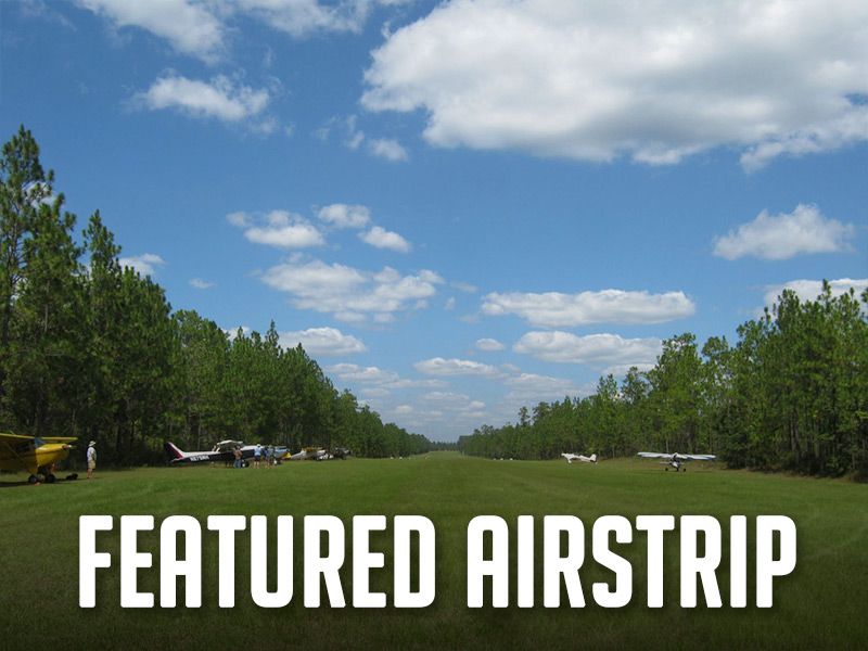
It’s flying season in Florida, and with mild seasonal temperatures and plenty of clear weather, it’s the perfect time to visit Blackwater Airfield, 8FD3 near Munson, FL. About 39 nm northeast of Pensacola, you can roll out on the smooth 4,000-ft turf airfield in the peaceful mixed pine State forest near Krul Lake Recreational Area. For years, the RAF has been especially proud of the many improvements brought about by hardworking volunteers with the help of RAF grants. Dedicated volunteers have worked together to preserve and improve this destination in cooperation with the Florida Department of Forestry. A scenic trail off the south end of the field takes you to 6.5-acre spring-fed Krul Lake for a refreshing dip. Wander a bit farther along the Sweetwater trail to the Sweetwater suspension bridge. Keep going eastward another hour to 107-acre Bear Lake, where a well-maintained trail circles the lake. To facilitate “leave no trace” use, you’ll find dumpsters in the campground. History buffs might enjoy exploring the nearby historic grist mill and Frick sawmill. As the sun dips low, your campfire comes to life, and so might the camaraderie with any others camped there. People gather for friendship and flying stories, and sometimes acoustic music breaks out beneath the starlight. If you happen to have your instrument, you’d be invited to join in! A team of RAF and other local volunteers recently spent a weekend refreshing the amenities, barbecue grills, and runway markings. “Arriving in twenty-one aircraft, it was an impressive turnout and a testament to the draw of Blackwater Field and the RAF community,” RAF Florida Ambassador Shane Hartman said, adding, “The sense of community that defines the RAF was on full display. From shared meals and campfire conversations to new friendships and lasting memories, Blackwater Field once again proved why it is such a special place.” For more information about Blackwater, and the required pre-arrival permission and safety briefing, see the Airfield Guide. By Carmine Mowbray Submitted December 29, 2025.
Payson, Arizona, is billed as “Arizona’s Cool Mountain Town,” and recreational aviators give it a big thumbs-up. The airport (KPAN) lies at 5,157 feet elevation beneath the Mogollon Rim and has become a favorite stop for pilots. It’s 50 miles from the hubbub of the busy Phoenix region, yet it offers all the amenities a recreational flyer could want – an uncontrolled, small-town airport – a natural stop for resupply for exploring Arizona’s other backcountry strips. It has 24-hr avgas and Jet A, and a courtesy car, available with 24-hour prior reservation, so you can explore the area and discover a wealth of outdoor recreation and historical sites, trails, and Native ruins. Camping among pinyon pines can start right at the Payson airport, where you’ll find a dozen campsites, each with a picnic table, grill, fire ring, and stocked firewood. Join new friends in the ramada, or around the group fire ring under the clear night sky. There are ADA restrooms with hot showers. The Crosswinds Restaurant is right on the airport and welcomes you for breakfast and lunch. Patrons highly recommend their pies. Payson has a very active Parks and Recreation department that organizes events throughout the year. Of special interest to aviators is their annual Aerofair in October. Admission is free, and the ramp is lined with all kinds of vendors and displays. You may see a Marine VTOL demo, a T-34 formation flyover, or strap in a Huey or a Cobra for a helicopter ride. You can choose from a mouth-watering variety of local foods. Experience community spirit during other warm weather events like free movies in the park, pro rodeo weekends, and golf tournaments. Fall brings public 5K run-walk events, flag football, and hay rides; and Christmas is lit up with the annual parade of lights. Payson gleams with community pride, and you can see the full story here . Find more about the Payson Airport in the Airfield Guide .
Mount Tobe, N41, is a gem of an airfield, supported by the RAF and very devoted local volunteers who raise money for maintenance during their annual Mt.Toberfest fly-in, coming up October 10-12. Thanks to RAF Connecticut Liaison Brian Thomas, two RAF grants have enabled volunteers to improve amenities at the airfield a
Recent Posts
Landing and camping at Taylor Flat airstrip puts your tent only a stone’s throw from the wild and scenic Green River, as it carves through spectacular Utah canyons. You can tie down and camp under your wing along the north side of the airstrip, or walk to the river and camp. Just 34 nm northeast of Vernal, you can now land at this high, remote BLM airstrip and enjoy its world-class fly fishing, but be sure to get your license before you arrive. If you packed your kayak or inflatable, there’s a boat ramp just west of the public campground. An easy 1.8-mile walk from the airstrip takes you to the historic 1880 John Jarvie Ranch, an open-air museum with hands-on exhibits showing pioneer ranch life in this remote northeast corner of Utah. This airstrip had lain dormant for thirty years, and is now open for public non-commercial use, thanks to pilots who recognized its special recreational value. The RAF worked through the steps to see that the BLM reopened it. One restoration work weekend brought twenty-five volunteers from both Utah Back Country Pilots (UBCP) and the RAF who hand-picked rocks from the airstrip, painted them, and used them to mark the runway corners and thresholds. UBCP provided a new windsock pole for the new RAF windsock. RAF Utah Liaison Wendy Lessig said, “It was another demonstration of working together toward the same goal.” There are no other amenities, so be prepared with what you need, and as always, please pack everything out. Those using the airstrip are asked to be mindful of the sensitive environmental area, marked with 16-ft X’s, creating a displaced threshold on the east end of the dirt runway. The useable runway length is 2,500 feet, and the field elevation is 5,630. The area east of the runway is hazardous to aircraft operations. In addition to being a sensitive environmental area, it. is cross-crossed with ditches, and is not safe for aircraft use. Taylor Flat is another special recreational destination for pilots to visit as RAF works across the country on Expanding The Map! Find more on Taylor Flat in the Airfield Guide . You may also find user reports here on the UBCP website . Submitted July 31, 2026 By Carmine Mowbray
RAF Maine Liaison Andy Rowe and former Maine Liaison/now Ambassador Steve Mason have long been advocating for and organizing improvements at several airfields in North Maine, in cooperation with North Maine Woods (NMW). Rowe was awarded an RAF grant for materials to add a shelter, picnic table, and outhouse at Estcourt Airfield (19ME) and organized RAF and NMW volunteers to provide labor.
The new Fly Rocky Top airstrip network, developed by the Recreational Aviation Foundation (RAF), is now open to backcountry aviation enthusiasts. Located in East Tennessee, Fly Rocky Top is a "basecamp and outpost" concept for regional aviation exploration, adding the Southeast to a growing collection of well-recognized recreational airstrip networks across the country, including Fly Oz in Arkansas and others in the West and Southwest. Fly Rocky Top is the most significant achievement to date of the RAF's Expanding the Map initiative, a nationwide effort focused on opening, improving, and restoring access to airstrips, helping connect aviators to more of the places they love to explore. Named and inspired by local culture, each Fly Rocky Top airstrip has unique features, amenities, and recreational options that embody the mission and spirit of the RAF. The new network is in the heart of a region nationally recognized for its unique topography that includes the Obed Wild and Scenic River, Big South Fork National Recreation Area, Cumberland Plateau, and Great Smoky Mountains… altogether a landscape uniquely suited to backcountry aviation. Rockwood Municipal Airport, RKW, anchors the network with its 2,400-ft manicured turf landing area and is designed with backcountry flyers in mind. Rockwood Aviation, which operates RKW, offers products and services for pilots to engage in tailwheel, backcountry, and recreational flying, including training, service, and support. City of Rockwood Mayor Jason Jolly highlighted the significance of Rockwood Airport to the community and East Tennessee. Mayor Jolly said, "We are a national recreation destination and the progress at Rockwood Airport and the surrounding network of airstrips is just the latest step in our region's growth and development for adventurers and enthusiasts." The Fly Rocky Top network is unique in that the initial collection of airstrips – with more planned – are a combination of both public lands and privately owned property with the common desire to welcome the flying public. Specific new airstrips in the Fly Rocky Top network include Smuggler's Landing, a grass landing area at RKW (with tent camping and a welcoming pavilion planned), McGraw's Backyard (5TN4), Robbin's Farm, and Tellico Plains (85TN). An additional outpost, Sawbriar, will be ready in August 2026. More airstrips are in the process of being added and will appear on the Fly Rocky Top webpage . Plans continue to add amenities to each RAF Fly Rocky Top airstrip, including accessible flush toilets and timber-framed shelters where camping is available. Other attractions include access to world-class upland bird hunting, hiking, some of the nation’s best trout fishing, kayaking/canoeing on the Clinch and Tennessee Rivers, and a 44-mile Water Trail on Beaver Creek. Select airstrips have access to meals and accommodations. RAF Co-founder and Chairman John McKenna highlighted what makes this opening so important. “Fly Rocky Top is not just a new airstrip network; it’s also a group of pilots who are passionate about aviation, stewardship, and the great outdoors,” he said. “Fly Rocky Top will connect Southeast pilots, landowners, and outdoor enthusiasts alike with the shared mission to preserve access to the region's wild beauty and outdoor recreational opportunities.”
RAF Montana Liaison Scott Newpower organizes the annual Montana Pilots Association and RAF cooperative work party at Schafer Meadows USFS airstrip, and on Saturday, July 18, nearly two dozen volunteers flew in to help. The airstrip lies in the Great Bear Wilderness, so work is limited to hand tools. A special thanks to Montana Aeronautics Aviation Support Officer Stephen Torske and the team at MT Aeronautics for their support.
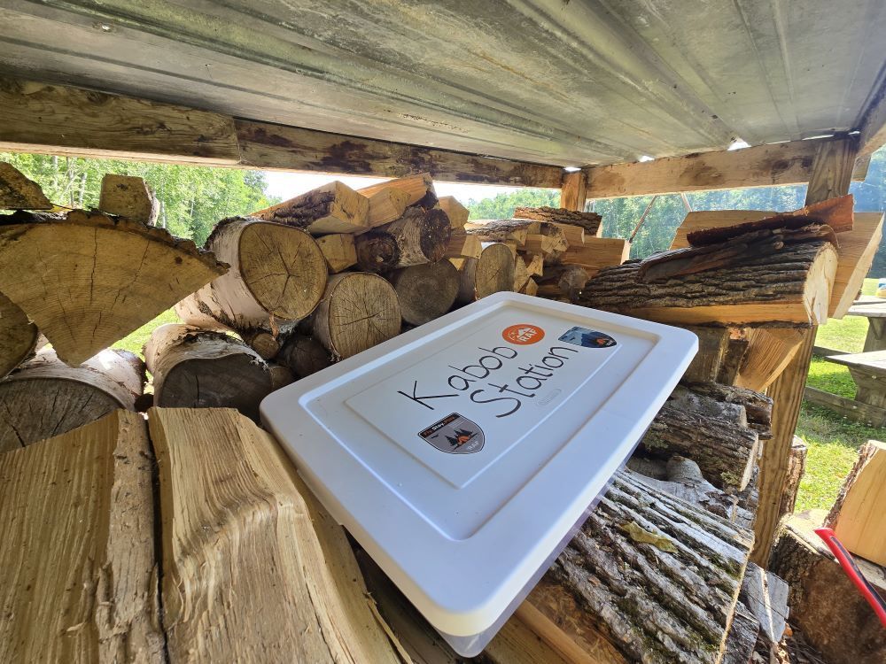
RAF Michigan Liaisons General Grant and Tanmoy Ganguly organized a work party July 11 at North Fox Island, 6Y3, the Lake Michigan island airfield just 24 nm northwest of Charlevoix. This year the work party added a new feature for visitors to enjoy – Tanmoy’s do-it-yourself RAF Kabob Station. The group cleared drainage ditches, cut out stumps, split and stacked firewood, cleaned up several miles of beaches, and trimmed and cleared four miles of trail. Grant thanked the volunteers for what he called, “A full day of work.” They gathered unneeded items and flew them off the island. Tanmoy is known for providing delicious kabobs at work parties, and debuted his RAF Kabob Station for pilots who want to cook up his legendary kabobs while on their own camping adventure. Many volunteers opted to camp for the weekend and enjoyed camaraderie around the campfire. See the Airfield Guide for more on North Fox Island. Please read the airfield Safety Briefing. Below it, you will now find a “Kabob Station” briefing. Submitted July 29, 2026