HERREN-BESS HOLLOW UPGRADES WITH RAF GRANT
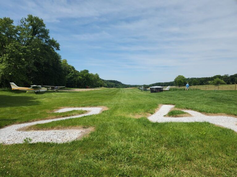
A runway with the number 24 painted on it

Herren-Bess Hollow airport, LL77 at Kamaroo Farms is as interesting a place as its name. Located near Kampsville, IL, the airfield has hiking trails, fishing ponds, and a “gold mine” for kids to explore. Exotic farm animals such as camels, kangaroos ostriches, and emus make this a family friendly destination.

The “Gold Mine” for kids to explore at Kamaroo Farms


You can camp under an old walnut tree and soon you’ll enjoy upgrades that Illinois Ambassador David Warner is adding thanks to an RAF grant. The airfield is 3,400 feet of maintained turf with clearly marked ends and displaced thresholds. The FAA restricts it to 1,924 feet due to terrain on each end. It’s near a population of active pilots, just north of the St. Louis Class B airspace, but can still be reached by unequipped aircraft. Warner is using the grant to provide a second windsock, and owners Mike and Tammy Herren will supply the post, concrete, labor and equipment to install it. The grant will also fund an improved RAF fire ring, and Herren will level, install, and provide pavers surrounding it.


The Herrens welcome visitors and continue to build attractions to those already available. “We stumbled on to one of their occasional crawfish boils last year when we dropped in to camp,” Warner said, adding, “The attendees really enjoyed themselves, and all were impressed by the quality of everything the Herrens did and their overwhelming hospitality.


The inviting field lies in hilly country between the Mississippi and Illinois rivers, very nearthe free Kampsville ferry that crosses the Illinois River. It runs 24 hours a day, seven days a week. The village of Kampsville is home of the Center for American Archeology that contains exhibits demonstrating evidence of 7,000 years of human habitation excavated nearby. Check their website for access information.


For more information on Herren-Bess airfield and the required safety briefing, see the Airfield Guide.


Submitted July 22, 2024
By Carmine Mowbray
    Recent Posts

July 24, 2026
RAF New Hampshire and Vermont Liaison John Meade was awarded a second grant for additional camping amenities at New Hampshire’s Parlin Field, 2B3. This time, the RAF has helped fund a covered camping shelter built by local volunteers for use in case of inclement weather. The shelter will soon have a roll-down tarp for use when occupied. Campers will also soon find solar shower bags and portable charging stations available at the campsites, as part of the grant. Pilots have enjoyed the six campsites with picnic tables and fire rings funded by a 2019 RAF grant, with local pilots providing the volunteer labor. “Over the past few years, the Parlin campsites have served pilots flying into New Hampshire to camp. I know that many visitors use this as a hub of operation to see all of New England,” Meade said. He points out that the FBO can be opened with a key code for access to a restroom and conference table. There are bicycles if one wishes to tour the Sugar Hill Trail System or ride the two miles to town for groceries – including local maple syrup – and restaurants. There is self-serve 100LL available. The field is both paved and has two turf runways. In May, Meade had organized volunteers to provide seasonal cleanup, in cooperation with Heath Marsden, part-time airport manager.  Find out more about Parlin in the Airfield Guide .
By lellington July 24, 2026
TX Ambassador
July 16, 2026
We have a BIG announcement planned for AirVenture this year, and you're invited to join us to celebrate the news. Put these special events on your AirVenture schedule for Tuesday, July 21: 8:30 - 10:30 am: Donuts & Coffee at the Redbird Booth, #301 11:30 am - 12:45 pm: RAF Forum - Beyond The Pavement by Mike Goulian, Forum Stage #10 We can't wait to share what our volunteers have been working on. Submitted June 15, 2026
By Carmine Mowbray July 14, 2026
“It's hard to describe the emotions associated with this effort,” said RAF California Liaison Katerina Barilov of the restoration of Monache Meadows airstrip, on the Kern Plateau south of California’s Mount Whitney. This High Sierra airstrip had been accessed for recreation for years until the US Forest Service unofficially closed it in the 1970s citing the Wilderness Act, although the strip is not in a Wilderness area; it lies between the Golden Trout and South Sierra Wildernesses. The RAF is thrilled to announce that Monache Meadows is officially charted as L80, and has been brought back into safe operation after many years of neglect. It is open for public access, thanks to years of effort and support by RAF volunteers and donors. RAF California Liaison Rick Lach first learned of the airstrip in the 80s on a Jeep excursion planting trout in the High Sierras. Lach became an RAF Liaison in 2011, and determined ways to approach the appropriate land managers about restoring the airstrip for use after being abandoned. Persevering for 15 years with respectful communications with a series of District Rangers, he finally delivered a breakthrough in 2024 when the Forest Service agreed to include Monache Meadows in its scope of work, allocating some funds in cooperation with RAF volunteer efforts. "After years of patience and persistence, I am glad to announce that we have restored Monache Meadows back to safe operation to be enjoyed by pilots once again," said Lach. Both Lach and Barilov organized repeated work parties, seeing as many as 20 volunteers making the arduous drive to help. A Monache resident and RAF supporter donated the windsock. The remote area is popular for camping, hiking, and fishing, and up until now was only accessible seasonally by a rough and rocky road, requiring high-clearance 4WD vehicles. The road becomes soft and impassable during wet conditions and closes due to snow. Barilov said, “We appreciate everyone's help. The strip ended up nearly 2,400 feet in length, is very flat, and is covered with grass. Frankly, it looks like one of the best grass airstrips I have ever landed on.” The airstrip lies at an elevation of 7,874, so those wishing to access it must consider density altitude, and that it seasonally gets heavy snows. The RAF's Expanding the Map initiative is a nationwide effort focused on opening, improving, and restoring access to airstrips, helping connect aviators to more of the places they love to explore. Learn more about Monache Meadows Airstrip and how the RAF is Expanding The Map . Submitted July 15, 2026 By Carmine Mowbray
By Matt Foster July 14, 2026
By Matt Foster - Safety, Education, and Etiquette Committee Chair Your backcountry adventure likely involves a heavily loaded airplane, a short strip, challenging terrain, and limited options. Your practice should reflect those realities – at your home airport. Weave exercises into your normal flying, and consider bringing someone along to observe and keep you honest. Make your normal operations backcountry-ready operations. Seek out an instructor with backcountry experience or challenge your local instructor to learn about your upcoming mission and play a role in your preparation. Load the airplane as you expect to fly it. Bring the camping gear, survival equipment, and ballast that simulates your expected weight and center of gravity. You’ll learn more about how the airplane performs when it's configured for the mission…not when it's empty and light. Make all your landings “spot” landings (remember: your “worst” landing is your standard). Know your performance for takeoff distance and power settings. Learn to lean for density altitude. Practice these calculations for your aircraft. Fly non-standard patterns where airports allow. Practice go-arounds with varying flap settings. Practice slow flight and canyon turns. You can do many of these on every local mission with only a little more thought and purpose…and it can be fun and rewarding. Visualize the adventure, and practice before you launch your adventure. The backcountry is no place to discover your limitations. Submitted July 14, 2026 Photo Credit: Bill Brine