AIRFIELD.GUIDE TAKES OFF WITH FUN PLACES TO FLY TO!
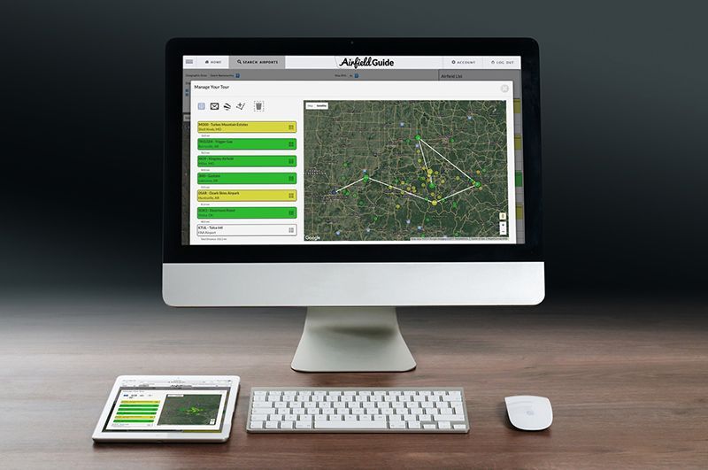
The idea of an airfield guide came about in response to repeated requests for a comprehensive listing of recreational places to fly. Created in cooperation between the RAF and Tailwind Aviation Foundation, all of the work is provided by volunteers. With its genesis in Arkansas, it began with a majority of Arkansas recreational airfields. RAF member and supporter Chip Gibbons began writing code and with the help of RAF Arkansas Liaison Dave Powell and others, began adding airfields and beta testing the program. They created a comprehensive survey form and RAF state liaisons were tasked with sending in appropriate airfields for consideration. Once the information is verified the location is added. 

It’s free to use, and once you’ve created a user registration, you receive updates of the new fields as they are added. See  airfield.guide  to register. 

The Airfield.Guide home page states, “New places. New adventures,” and as of this writing, the site lists 231 airports, with 56 in Arkansas; Missouri is second highest with 18; Montana third with 17; Oregon comes next with 15, followed by Oklahoma with 14. As advertised, the geographic region has grown – 49 of 50 states are now represented – with more recreational airstrips and airfields added all the time. Airstrips are defined as two types, Permissive (green), where users don’t need to ask for permission; and Conditional (yellow), where a condition needs to be met before use, such as a required Safety Briefing; or prior contact with owner. These are clearly defined in the Airfield.Guide.

You’ll find the many features of the Airfield.Guide very helpful in planning your flight. You can sort by recreational amenities (camping, restrooms, fishing, cell service, etc), runway length, region, state or RHI, Relative Hazard Index, where full airstrip surveys have been completed, (RHI is based on Galen Hanselman’s rating system). Many airstrips include photos, and even videos of approaches and landings. The “Manage Tour” feature can be used to plan a flight of several locations, email it to fellow pilots, then all can upload to ForeFlight for navigation to those strips. Additionally, you’ll find the basics, lat/long, elevation, ownership, pattern direction and CTAF.  Going forward,   The Airfield.Guide is also where you’ll find important Safety Briefings developed for specific airstrips, some of which are required to be reviewed prior to landing  and again, details to gain knowledge to help you make appropriate decisions before you fly there.

RAF President Bill McGlynn said, “This is an important focus for us in 2020. We would like to double the number of airfields in the Airfield.Guide.”

The RAF thanks the Tailwind Aviation Foundation, Powell, Gibbons and each state liaison for contributing potential airstrips.

Submitted on February 26, 2020


Posted in News

    Recent Posts
By Carmine Mowbray July 14, 2026
“It's hard to describe the emotions associated with this effort,” said RAF California Liaison Katerina Barilov of the restoration of Monache Meadows airstrip, on the Kern Plateau south of California’s Mount Whitney. This High Sierra airstrip had been accessed for recreation for years until the US Forest Service unofficially closed it in the 1970s citing the Wilderness Act, although the strip is not in a Wilderness area; it lies between the Golden Trout and South Sierra Wildernesses. The RAF is thrilled to announce that Monache Meadows is officially charted as L80, and has been brought back into safe operation after many years of neglect. It is open for public access, thanks to years of effort and support by RAF volunteers and donors. RAF California Liaison Rick Lach first learned of the airstrip in the 80s on a Jeep excursion planting trout in the High Sierras. Lach became an RAF Liaison in 2011, and determined ways to approach the appropriate land managers about restoring the airstrip for use after being abandoned. Persevering for 15 years with respectful communications with a series of District Rangers, he finally delivered a breakthrough in 2024 when the Forest Service agreed to include Monache Meadows in its scope of work, allocating some funds in cooperation with RAF volunteer efforts. "After years of patience and persistence, I am glad to announce that we have restored Monache Meadows back to safe operation to be enjoyed by pilots once again," said Lach. Both Lach and Barilov organized repeated work parties, seeing as many as 20 volunteers making the arduous drive to help. A Monache resident and RAF supporter donated the windsock. The remote area is popular for camping, hiking, and fishing, and up until now was only accessible seasonally by a rough and rocky road, requiring high-clearance 4WD vehicles. The road becomes soft and impassable during wet conditions and closes due to snow. Barilov said, “We appreciate everyone's help. The strip ended up nearly 2,400 feet in length, is very flat, and is covered with grass. Frankly, it looks like one of the best grass airstrips I have ever landed on.” The airstrip lies at an elevation of 7,874, so those wishing to access it must consider density altitude, and that it seasonally gets heavy snows. The RAF's Expanding the Map initiative is a nationwide effort focused on opening, improving, and restoring access to airstrips, helping connect aviators to more of the places they love to explore. Learn more about Monache Meadows Airstrip and how the RAF is Expanding The Map . Submitted July 15, 2026 By Carmine Mowbray
By Matt Foster July 14, 2026
By Matt Foster - Safety, Education, and Etiquette Committee Chair Your backcountry adventure likely involves a heavily loaded airplane, a short strip, challenging terrain, and limited options. Your practice should reflect those realities – at your home airport. Weave exercises into your normal flying, and consider bringing someone along to observe and keep you honest. Make your normal operations backcountry-ready operations. Seek out an instructor with backcountry experience or challenge your local instructor to learn about your upcoming mission and play a role in your preparation. Load the airplane as you expect to fly it. Bring the camping gear, survival equipment, and ballast that simulates your expected weight and center of gravity. You’ll learn more about how the airplane performs when it's configured for the mission…not when it's empty and light. Make all your landings “spot” landings (remember: your “worst” landing is your standard). Know your performance for takeoff distance and power settings. Learn to lean for density altitude. Practice these calculations for your aircraft. Fly non-standard patterns where airports allow. Practice go-arounds with varying flap settings. Practice slow flight and canyon turns. You can do many of these on every local mission with only a little more thought and purpose…and it can be fun and rewarding. Visualize the adventure, and practice before you launch your adventure. The backcountry is no place to discover your limitations. Submitted July 14, 2026 Photo Credit: Bill Brine
July 14, 2026
The annual Meadow Creek, Montana cooperative work party occurred on June 20. Volunteers from Montana Pilots Association, Montana Aeronautics, and the RAF flew in to do seasonal maintenance together on this popular NW Montana Forest Service airstrip adjacent to the Bob Marshall Wilderness. 
By Carmine Mowbray July 14, 2026
RAF New Hampshire Liaison John Meade originally came on board as Liaison in 2016 and has recently volunteered to add Vermont to his Liaison role. We are thrilled to have his help in both states going forward. John grew up in New York and had the Navy take him away; eventually depositing him in Massachusetts. John’s father-in-law was a pilot, and in the late 80s, John got bitten by the flying bug as well. Eventually, a SuperCub on floats became his pride and joy. It became a convertible with Bushwheels, skis, and floats. He credits his association with SuperCub.org for coast-to-coast friendships and finding a cadre of local New England pilots in search of backcountry adventures. John’s current airplane is a Bearhawk Patrol that he built. John and his wife Jennifer split their work week between Massachusetts and New Hampshire, where they have a home and airfield. Their Wentworth Aerodrome – affectionately known as the “WAD” – is located 12 miles from Vermont, where he flies routinely. John has one son and five grandchildren. RAF NH/VT Liaison John Meade can be reached at jmeade@theraf.org . Submitted July 14, 2026 By Carmine Mowbray
By Carmine Mowbray July 14, 2026
RAF Supporter Chris Erkmann lives in Chesterfield, Missouri – about 20 miles west of St. Louis, midway between the airfields at Trigger Gap, AR and Henderson, IL. He has flown his 1962 Cessna 182 into both places to volunteer at work parties alongside other RAF supporters.