RAF REPRESENTED ON HELLS CANYON RECREATION ACCESS COUNCIL

Hells Canyon, North America’s deepest river gorge, encompasses a vast and remote region with dramatic changes in elevation, terrain, climate and vegetation. Carved by the Wild and Scenic Snake River, Hells Canyon plunges more than a mile below Oregon’s west rim, and 8,000 feet below snowcapped He Devil Peak of Idaho’s Seven Devils Mountains. 

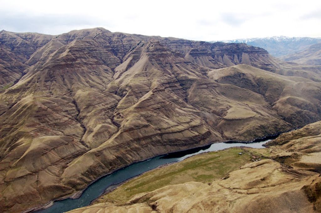
The Hells Canyon National Recreation Area (NRA), managed by the US Forest Service (USFS), encompasses 652,488 acres of rugged backcountry hugging the borders of northeastern Oregon and western Idaho.  There are no roads across Hells Canyon’s 10-mile wide expanse, and only three roads lead to the Snake River between Hells Canyon Dam and the Oregon-Washington boundary.  However, there are seven backcountry airstrips deep in the canyon along the Snake River.  Six of these airstrips are open for public use under direction from the 2003  Hells Canyon National Recreation Area Comprehensive Management Plan.  

RAF Oregon Liaison Richard Mayes has been invited to join the Hells Canyon Recreation Collaborative (HCRC) whose mission is to:

“Work collaboratively to maintain and improve recreation access into the Hells Canyon National Recreation Area by boat, raft, foot, vehicle, horseback, aircraft and associated historical infrastructure by making recommendations to the US Forest Service; promoting a sustainable recreation experience through the involvement of a broad group”.  

Richard attended the December monthly HCRC meeting in Riggins, ID.  The more than 35 participants at the meeting included representatives of the USFS and State agencies, various commercial and recreational users, and representatives of Idaho’s congressional delegation.  Discussions included progress of ongoing infrastructure improvements at Pittsburg Landing and the need to undertake protection of the historic Kirkwood Ranch complex, downstream of the Big Bar airstrip. 

Richard is working with the HCRC Steering Committee and fellow RAF member Bill Ables to protect and improve access to the six public use airstrips.  In collaboration with the Idaho Aviation Association, efforts are ongoing with the USFS to find an acceptable approach to reopen the seventh airstrip – Sluice Creek, which is currently off-limits.

Submitted on December 20, 2018


Posted in News

Recent Posts

March 30, 2026
As you're planning your 2026 flying adventures, remember to review safety briefings for the airstrips you plan to visit. The RAF strongly recommends you review safety briefings and print a copy to have in your airplane - it's even required to fly into some airfields, like Ryan Field (2MT1). For those airfields, pilots flying in are required to review the briefing on an annual basis, and now is the perfect time to catch up on any changes to the runway/area that happened throughout the winter. You can find safety briefings on the RAF Airfield Guide . If an airfield in the Airfield Guide has a required briefing, the airfield listing will clearly indicate it and have a tab to view the briefing. Submitted March 30, 2026 Photo By Jim Stevenson
March 30, 2026
RAF Texas volunteers and Ranger Airfield Foundation volunteers helped begin restoration of the historic 1928 Ranger Airfield hangar on March 28. “A Wright biplane landed here at the field in 1911, and people have been using it ever since,” Ranger Airfield Foundation Founder Jared Calvert said. He noted that Amelia Earhart landed there in a Pitcairn Auto Gyro. Richard Bach, Pancho Barnes, and General Patton also landed at the field. It’s the oldest continuously used turf field in Texas. 
By Carmine Mowbray March 30, 2026
For adventurers seeking access to the Gila Wilderness, we suggest landing at Sacaton Airstrip, NM16, near Buckhorn, New Mexico. The runway lies on a “finger mesa,” and the Rain Creek trailhead lies just northeast of the field. Thanks to RAF New Mexico Liaison Ron Keller's coordination with the USFS using a Cost Share Agreement, Keller was able to organize RAF and New Mexico Pilot Association (NMPA) volunteers to rehabilitate and reopen the long-abandoned airstrip in 2022. Beyond reopening the airstrip, Keller added camping amenities, including picnic tables and a new vault toilet. Most recently, Keller oversaw the installation of new shade structures, most welcoming to campers and hikers. RAF and NMPA volunteers complete ongoing maintenance at Sacaton and other airfields in the Gila National Forest. You’ll see white-painted rocks along Sacaton’s 3,989-ft dirt runway, and surrounding the segmented circle near the RAF windsock. The airstrip lies at 6,200-ft elevation, so pilots should be mindful of density altitude while flying over high terrain in the vicinity, even in winter temperatures.  “Anglers will enjoy plying streams for the rare native copper-colored Gila trout, once a threatened species,” Keller reports. The mile-and-a-half trail to the crossing at Rain Creek is narrow and challenging and traverses a variety of terrain, but the serious hiker will be rewarded trekking through steep canyon walls lined with green alder, willow, and boxelder, hoodoos, and eagle aeries above. There are rumors of a double waterfall some distance on the west fork of Rain Creek trail. See the Sacaton page in the Airfield Guide for more details. Note that the airstrip may be unusable due to snow or after heavy rains. This runway should be considered one-way in/one-way out to avoid overflying the Wilderness boundary. There is a 4.6% upslope to the East, favoring landing Runway 08 with right traffic, remaining clear of the Wilderness east and north of the airfield. Please consider others seeking a Wilderness experience. Prior to landing at Sacaton, permission is required by calling the USFS Gila Dispatch center at 800-538-1644. Please familiarize yourself with Sacaton in the Airfield Guide and the New Mexico Pilots Association Safety Briefing . Submitted March 30, 2025 By Carmine Mowbray
By lellington March 29, 2026